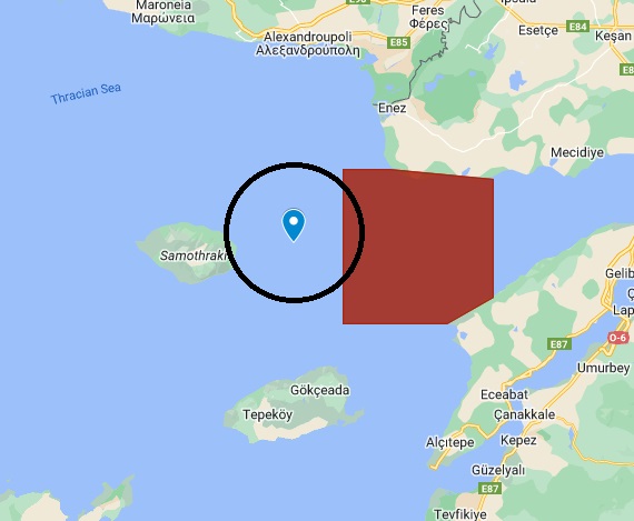

Continuing its revisionist policy in 2024, Turkey has once again set its sights on the islet of Zourafa, east of Samothrace.
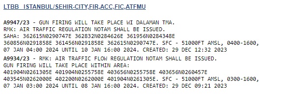
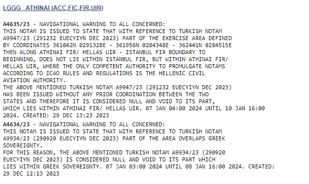
By issuing the NOTAM A9934/23, the Turks committed an area that closes the whole bay of Xeros, from 7 to 8 January 2024 for a firing exercise. The western part of this area, however, steps on part of the national airspace emanating from the Zourafa islet.
It is of course neither the first nor the last time as Turkey has also relatively recently with a fire exercise acted as if Zourafa did not exist.
Foreign Minister George Gerapetritis said at the end of November: "The Zourafa islet belongs to the Athens FIR. The Turkish announcement, the NOTAM, as well as all the relevant NOTAMs, made no reference to Zourafa, and therefore the issue of Greek sovereignty over the Zourafa islet cannot be questioned.
What the NOTAM defined was an area where firing was to take place and which did not include Zourafa, but a part of Greek airspace, and that is why a NOTAM was issued by the Air Force, which in fact cancelled the Turkish announcement for the part of the overlapping Greek airspace. During the exercise there was absolutely no violation of Greek airspace by Turkish fighters."
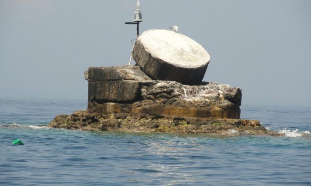
According to the study by George Giagakis "ZOURAFA MAS: Northeastern insular promontory of the country" we read among others:
"Zourafa (Ladoxera) with a surface area of 9 acres and a coastline of 465 meters according to earlier measurements of the Hydrographic Service of PN, while according to more recent calculations it is less than one acre and has a shoreline of 32 meters, is low and therefore extremely dangerous, especially with unfavorable visibility conditions for those sailing east of Samothrace, from the northeastern end of which (Akra Agistro or Skepasto) is about 6 nautical miles away. From this point an individual distress light with a flashing white light shall be operated.
The metal pyramid of the lantern is painted black with a red stripe. Depths of less than 10 metres are located up to a distance of about 100 metres around it.
It is about 22 nautical miles from the lighthouse of Alexandroupolis, is a remnant of a volcanic island and a significant eastward current has been observed near it. Its wider area is a rich fishing ground, where fish of all kinds still frequent...Thanks to its dominance, Greece is significantly expanding its zones of maritime dominance (territorial waters, etc.) in the critical area of the North-East. Aegean Sea, towards the East.
The strait between Zourafa and Akra Gremia (today Boztepe Burnu, Eastern Thrace) has a width of about 14 nm. In the past, several ships, trying to avoid the approach to Zourafa, had run aground on the rocky islands surrounding Akra Gremia. How many Greeks are aware of the existence of Zourafa, which lies East of Samothrace, North of Imbros and South of Alexandroupolis and which most of our maps circulating for the general public (school maps, tourist maps, etc.) are scornfully omitted, although it marks the boundaries of the Greek Territory."
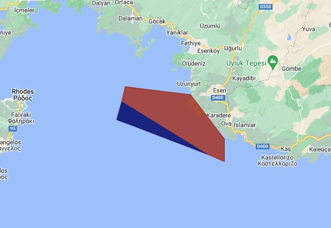
At the same time, Ankara with another NOTAM, the A9947/23, blocked the area between Kastelorizo and Rhodes from 7 to 10 January, also for fire drills. As in the case of the exercise overlapping Greek airspace in the area of Zourafa, Athens reacted with an anti-NOTAM. In this case Greece stressed that from certain coordinates onwards the area is within the Athens FIR and therefore for this part the Turkish NOTAM is invalid.